Sunday, November 20, 2011

Wednesday, November 2nd : Chilly at Canyon De Chelly

Today, we decided to explore the canyon. There are 2 rim drives: the north rim and the south rim. We decided to do the south rim because there are more overlooks and because there is a hiking trail down to White House ruins, the only trail down into the canyon that does not require a guide. We drove the 10 miles to the last overlook first.
Here we are with Spider Rock in the background

This was the Spider Rock Overlook where we were able to view the famous rock column protruding from the canyon floor. The canyon walls are made of that southwestern red rock and rise vertically to about 700 feet above the valley floor. The valley is very narrow, maybe only 1000 yards. The Navajo have ranches and small farms on the almost flat valley floor. A shallow river meanders thru the valley and dirt road follows it. Cottonwood trees form small groves on the valley floor and at this time of year, the leaves had turned a beautiful yellow color. Contrasting the yellow of the cottonwood trees against the red rock walls and the dark blue sky of that day made for a beautiful photo shot. It was about noon and the temperature had just inched above 40F, so we were all bundled up. From that vantage point, we could see cliff dwellings in the opposite canyon walls. I had brought along my compact binoculars, so we could get a good look at them. We turned around and drove back down the south rim road, stopping at Face Rock Overlook and Sliding house overlook, again looking at the beauty of the canyon from a different vantage point and at the cliff dwellings on the opposite canyon wall.
Jan in one of the trail tunnels

The next stop was the White House Overlook from which the trail leads down into the valley. Since none of the overlooks had toilets and we were looking at a 2 hour hike, we decided to drive back to the visitor’s center to use their facilities and then drive back. When we got back, we bumped into Steve & Diane at the overlook. They weren’t going to hike down the trail as they were more the ATV type, so we left them and headed down the trail. The canyon rim was a straight down rock cliff, so they had cut a tunnel through the rock to get the hikers through that portion. After that, the trail was a series of switch backs and a few places with steps, either cut into the rock or dirt filled with small logs holding back the dirt. Near the bottom of the trail was another tunnel, which then led to the flat valley floor. To our immediate right was a fence on which a sign read “private residence, no pictures please”. In about 1 acre of fenced in area, there was a Hogan style Navajo house, a few barnyard animals, and nothing much else, essentially a very humble household. We walked across the river, which was only a small stream now, on an iron grating bridge and then on down the river to the usual Navajo vendors selling the usual necklaces, bracelets, and rings. Not that the wares were not pretty, but they are selling these everywhere you turn.
Looking down onto the canyon floor

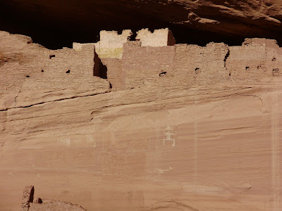
Twice we had a Navajo vendor knock on or trailer door wanting to sell us something. They are very polite, but persistent. Having already bought 2 necklaces, we passed on the jewelry. It was nice being in the valley as it gives you a different perspective of the canyon. We were a little disappointed because we were only able to get within about 200 feet of the ruins as there was a high wire fence keeping us at bay. There were some petroglyphs on the canyon walls near the ruins, so I took some pictures of those and of the ruins. It was sad to see that part of the ruin had graffiti written on it. When that happened and by whom, we never did find out.
Petroglyphs at The White House

Jan was anxious to get back as it was getting late in the afternoon, so we headed back without lingering any longer. Of course, the hike back was harder than the walk down and we both were breathing hard as we walked back up. Jan said afterward that she didn’t think she was going to make it, but she trooped on. I kept reminding her of the benefits of strong exercise, but I don’t think she was impressed at the time. After that, we went back to the trailer, had some dinner and crashed.

Dave in front of The White House
Some of the cliff dwellings as seen from the other side of the valley

Yellow cottonwood trees against the red rock against the blue sky: beautiful!

Tuesday, November 1st: We drive to Canyon de Chelly National Park

Canyon de Chelly was only about a 2 hour drive, so we were not in a great hurry to get going early. In fact, we did not leave Cadillac until around 12 noon. We stopped at the 1 small grocery store and gas station in town to buy something for lunch before we left. They had a 2 for 1 special on hamburgers, but when I ordered it, she said that it would take ½ hour to prepare! (I guess that’s what it was like before McDonalds) So we ordered a couple of sub sandwiches instead.
We drove a few miles down the road to our 1st turn off where we found a large area beside the road to pull off and eat our sandwiches. The drive was uneventful as we drove the back roads of southern UT and northern AZ, watched the beautiful desert scenery of large open spaces and mesas, and looked at the scattered Navajo farms and ranches. We needed propane, so we stopped at a store in a place called Many Farms. We were still on the Navajo reservation, so we were the only “white men” around. I paid inside and carried my propane tank over to the large propane tank, where another Navajo fellow was having a very tall tank filled. This guy was a little wiry guy who was getting on in years and had a Fu Man Chu looking beard. I asked him how much his tank weighed when it was full and he said about 100 lbs. I asked him if he could lift it into his truck and he said, “Sure” and flexed his arm muscles to show me his verility. However, when it came time to put the tank into his pickup, I noticed him struggling, with the tank partially on the truck tailgate and not moving any further. I walked over and gave him a hand and we both got the tank into the truck. The Navajo guy pumping the propane told me that he was a civil engineer surveyor, but couldn’t find work, so he had to do this. I just told him that there were a lot of people in the same situation, but that was probably of little consolation.
We pulled into Chinle, the town where Canyon de Chelly is located. We were excited to see a Burger King as we hadn’t seen one since we left Cortez. It was only about 3:30 P.M., so the visitor’s center was open. Jan had her passport stamped, we got a pamphlet, and then headed to the campground. The campground was in a grove of cottonwood trees, had paved roads, restrooms with flush toilets, and a dump station, but best of all, it was free! When we pulled into our spot, we noticed the same Montana 5th wheel that was next to us at Goosenecks! It’s a small world. This time when I saw the couple that owned the rig, I remarked on what a coincidence it was that once again, we were neighbors. They introduced themselves as Steve & Dianne from British Colombia and invited us over for cocktails after we got our rig set up. We did go over there and another couple from Canada joined us.  Steve & Diane had been full timing since June 2010, exactly 1 year longer than us. They said that they’d been planning to do this for 20 years and love it. The sun went down & it got chilly, so we all retired to our respective trailers.

Monday, October 31st – Spending the day in Bluff, UT

We had considered driving north to Canyonlands, Bryce Canyon, and Zion, but the weather was trending colder and the long range weather forecast was for inclement weather, so we decided to head south. We were going to spend another night at Goosenecks, but our water and power were getting low and our waste tanks were getting high, so we decided to hop on over to Cadillac RV Park for full hookups in the very small town of Bluff, UT. There, we would also be able to have access to the internet through the campgrounds Wi-Fi network. At Goosenecks, Verizon had no signal, so our Ipad and main cell phone did not work. However, my humble Tracfone had 5 bars so we were at least connected to the outside world through that. This was an uneventful day as we drove for about 40 minutes, paid our $27, hooked up, and relaxed for the rest of the day.
The park had a small lake with picnic tables around it about 150 feet from our trailer. It seemed that it would be a nice place for a picnic if the weather was warmer. This RV Park had cottonwood trees as it was near the river and I presume that the soil was wetter allowing the trees to grow.

Sunday, October 30th: Natural Bridges National Park

At a distance from our trailer, we watched John pack up his car and then we headed off to Natural Bridges National Park. John had warned us that there was a steep and narrow part of the road that climbed the mesa. As we drove north, we saw the road head straight for the cliff face of the mesa. “There is no way that road is going up that cliff”, I said to Jan, but as we began to wind up the switchbacks, we could see other cars high above us on the cliff face. As we climbed, we could see that the road was literally cut out of the rock.
Dave, on top of the mesa looking towards The Valley of the Gods

On top, we could see the whole expanse of the valley with The Valley of the Gods to our left and Monument Valley to our right. As we looked down in amazement, we could see some yahoo driving up the road towing a trailer, which was in turn towing a boat! A sign at the bottom explicitly said, “No RVs, buses, or vehicles towing anything. We never found out if he made it or not. We continued on across the mesa for about 30 miles and arrived at Natural Bridges. At the visitors center lobby, there was a 16.5” telescope that had been donated by a private party. I drooled over it as I had seen that model for sale from a small company on the internet. Jan got her usual magnet and her passport stamped, and we headed to the picnic area. There wasn’t a cloud in the sky that day and it was about 60 degrees, but a little breezy at the canyon tops. The picnic area parking lot was filled with 2 big rigs and their toweds (RVer slang for towed vehicles), so we went drove on to the trail head for a look at the first of 3 natural bridges and ate our brown bag lunch in the car.
Jan & Dave near the arch
We had to hike 500 vertical feet down into the canyon on a trail that consisted of switchbacks, steel stairways, and a rustic ladder make of tree branches (I guess to give the visitor a feeling for the way the Indians did it). A lady who was standing near the top of the ladder said that see did not have the balance to go down the ladder and that her husband had gone on ahead. We climbed down to a vantage point which was about half way the height of the arch and stopped there, since Jan’s knee was bothering her and there seemed to be no advantage in going under the arch. We took pictures of each other, and then the lady’s husband came down the trail and offered to take our picture. When he left, another young couple appeared and I took their picture. We turned around and made it back to the top and then stopped at the overlooks for the 2 other natural bridges.
One of the other arches (very thin at the top)

We came back to Gooseneck via a different, although longer route, which had no winding steep roads. We had a nearly empty propane tank with us, but could not find propane in the only town that we passed through, Bluff. Since we had an hour or 2 of sunlight left, we decided to drive the 17 mile loop through the Valley of the Gods. It was kind of a Monument Valley in miniature, but we actually liked it better than Monument Valley because you could get closer to the monuments and they were closer together and more numerous. The only bummer was that the gravel road was very bumpy with lots of wash boarding, which make the truck shake violently.
Jan in The Valley of the Gods

We got back as the sun set and soon after there were the clearest starry skies I’ve ever seen. I was exhausted though and didn’t have the energy to set up the big scope, but I did view a couple of galaxies with my small scope.

Saturday, October 29th: Monument Valley

Jan on our morning walk. Our trailer is the white spec on the right.
Looking back at our trailer from the canyon rim finger
We got up to a chilly, but clear morning and decided to take a walk down the dirt road that leads out to a narrow finger of the canyon rim. In one place, the finger was only about 100 feet wide with 1000 foot cliffs on both sides. The mesa was perfectly flat with different little desert sage plants scattered everywhere. We could look back at our trailer parked on the canyon rim and it looked like a child’s toy. When we got to the end of the finger, we could see the river winding down below in a steep gorge. Other gorges feed into the serpentine canyon, but they were dry now as the rainy season had ended. One of the feeder streams looked like it had a nice waterfall as a hard layer of what looked like slate kept the water from digging further down into the gorge. As we walked back to the trailer, we stopped by John’s campsite and asked him about his neighbor with the generator. Apparently, it ran all night. I invited him to over to our trailer for some star gazing thru my 14” telescope that night.

The Mexican Hat rock
Some of the rock formations in Monument Valley
We hopped into the truck and headed to the town of Mexican Hat and onto Monument Valley, which was a 30 to 40 minute drive. Mexican Hat is famous for a rock that looks like a Mexican sombrero that precariously teeters on top of a rock column. Before we entered the town, we could see the rock about ½ mile away on our right. We needed some groceries, but the town didn’t seem to have a grocery store per sie so we drove on to Monument Valley. From the top of Monument Pass looking west, there is a famous picture of the highway leading down to the valley floor and out to the majestic rock formations. I always wanted to be in that spot and I finally was. The monuments were large, but they were very far apart and we couldn’t get close to most of them as the surrounding land was privately owned by the Navajo Indian Nation reservation. We noticed that there was a grocery store nearby the road junction, so we stopped to buy some groceries. We were a little disappointed; however, because they didn’t have our favorite sugar free fudgesicles, in fact, I don’t think there are any sugar free fudgesicles in all of southern Utah!
Jan in Monument Valley

When we got back, we started setting up the big telescope for the night’s viewing. Clouds had rolled in, but they passed over as the night got darker. The moon was a thin crescent and the planet Mercury could be seen on the horizon. What is so great about the desert is that the horizon is unobstructed in every direction and at this place the sky is dark in every direction as you are out in the middle of nowhere. As it got darker, I looked at the planet Jupiter and then some of my favorites: the Andromeda Galaxy and its companion galaxies, The Great Globular cluster in Hercules, the globular cluster M22 in Sagittarius, the Ring Nebula, and the Dumbbell Nebula. John dropped by, and we looked again at Jupiter, then again at Andromeda, and finally the seven sisters. With the sky that dark, we could just make out the Andromeda Galaxy with our naked eyes. Imagine seeing something 2.2 light years away with just your eyes! It was getting cold, so John left and we retired for the night.

Friday, October 28th: Cortez to Four Corners to Goosenecks

Here we are, standing in 4 states!
The next morning, I finished up wiring up my battery condition meter and got the propane tank filled at the “Big R”, but it still took us until 12:19PM to hook up the trailer and leave. Checkout time at the Sundance RV Park is noon, so we were a little late. We calculated that the drive to Goosenecks State Park was only about 2 1/2 hours away, so we weren’t in a hurry. The road took us through the 4 corners of the states of Utah, Colorado, New Mexico, and Arizona. There is a National Monument there that is administered by the Navajo Nation. The monument was a big slab of concrete with a big “+” in the center with the names of the different states in each corner. A bunch of flags on tall polls surrounded that and then a bunch of booths surrounded that where the Navajos sold their jewelry and pottery. As we stepped towards the big “+”, another couple asked if we wanted them to take our picture and we said, “Sure”. Jan thought that she had recognized their rig from Sundance and asked them if they had stayed there the night before and they had. They were also full timers and had been on the road since June as we had, but had been on several long trips before that. We talked to them for a while and compared notes on the places that we’d been, renting our houses, and the Quartzite AZ RV gathering every Jan-Feb. We bid them farewell and looked at some Navajo crafts for sale. Jan picked up a nice turquoise necklace and Christmas ornament. We also bought postcards and a magnet. There was a little shack nearby that served Indian bread. We were curious, so we stopped in to find that Indian bread was deep fried bread with a choice of sugar & cinnamon, powdered sugar, or honey topping. We chose the sugar & cinnamon. I thought it was quite good, but Jan didn’t like it that much as it was too greasy. As we drove through the Navajo Indian Reservation, we could see scattered ranch type dwellings, but the land they were on is very meager and most of the houses were run down trailers or shacks, so it looked like they were barely surviving.

The view from our trailer window
The road to Goosenecks State park is very Thelma & Louise-like. If you don’t stop at the stop sign at the end of the road, you go careening off the 1000 foot cliff. There is one pit toilette there and a dirt road that runs along the canyon rim. Another Montana 5th wheel had taken the nearest spot, so we pulled into the next spot that was about 200 feet down along the canyon rim. We parked about 15 feet from the cliff edge, so we could see the $1M view, which we paid zip for because camping is free there! The skies there are some of the darkest in the country, so as it started getting dark, I took out my little 4" refractor telescope and started looking at the sky. Jan came out and sat in the chair for a while. She got up and walked to the back end of the trailer where she almost bumped into a man who was walking back to his tent, but stopped by to ask us if we thought if it was O.K. to move his neighbor’s generator to the other side of his truck. The man’s name was John. He was from Minnesota and was camped in a tent several hundred yards down the canyon rim from us. Apparently, a pickup truck with a camper shell had stopped to camp near his spot. A guy got out, hooked a generator, and promptly got back into his truck. John had camped out there to find some peace & quiet and now he had to listen to the guy’s generator! John had told us that he had knocked on the truck door and shouted “Hello” several times, but no response. We said that he better not try moving it as you never know who you are dealing with. We talked for a while and John went on his way back to his noisy tent.

Thursday, October 27th: Mesa Verde National Park

With the weather improving, we decided to go visit Mesa Verde. The entrance to the park was only about 9 miles out of town, but there was a 45 minute drive to get to the museum and cliff dwellings. We stopped at Subway on the way out of town and ate our sandwich as we stopped at an overlook of the valley. The park road meandered up the mesa with a few switch backs and we even went through a tunnel. The tops of the mesas were above 8000’ and valley floor was around 6000’, so it was about a 2000’ climb. The visitor’s center was closed for the season, but the museum, which sat on a canyon rim above one of cliff dwellings, was open. The museum was small, but actually quite nice. Jan bought a magnet, some postcards and had her passport stamped. We looked at the exhibits at the museum for about ½ hour. I wondered why these Native Americans lived up in these mesas and not down in the valley, where it seemed to be much nicer. As it turns out, most of the native population did live in the valley, while these peoples chose to live up in the mesas, just as people choose to live in different parts of the country today. They dry farmed on the mesa tops and lived under the natural protection of the cliff overhangs for hundreds of years up until about 1300 AD.
Spruce Tree House from the trail top
We hiked the trail from the back of the museum about 100’ down into a small canyon to look at the Spruce Tree House dwellings. The walls are made of mud brick and the rooms are really tiny. In some places there are 3 stories with balconies. They had dug a lot of these round holes about 14’ in diameter and about 9' or 10’ deep called Kivas. The roof was made of tree branches with bark and mud and there was a square hole in the top where a ladder is placed for access.


Dave at the Spuce Tree House

Of course, the roofs where gone long ago, but the park service re-built the roof on one of them, so Jan & I climbed down into to one to have a look. It must have been nice and cool in the summer and warm in the winter as there was a place for a fire in the center and a ventilation shaft.

Cliff Palace
Jan climbing out of the canyon
After we walked back out of the canyon, filled out our post cards and mailed them at the tiny 1 woman post office that they had there. We went back into the museum and bought tickets for the 4 o’clock ranger guided tour of the Cliff Palace, which was another ruin a few miles away. When we arrived at the top of the trail head, the ranger told us that we would have to climb several 3 meter ladders. This made Jan very nervous as she did not like climbing ladders. This I didn’t know, but as I remember back to all of our house fixing and painting days, she never did climb any really high ladders, but I just assumed that was because my job was to do it. As it turned out, the ladder climbing wasn’t as bad as we had thought and it was actually quite fun. This cliff house was a lot like the other cliff house only bigger. The ranger did a good job of telling us about the daily life of the cliff dweller. It was interesting that the average height of a man was only about 5’2” to 5’4” and he only lived to be 25 to 35 years old. The woman died even younger. They were married at 13, had 6 kids (3 of which died either at childbirth or an early age) before they were 20. Some people on the tour remarked that they must have had little time to pass on their culture to their children before they died. I thought of how fast the generations must have passed!

Wednesday, October 26th: Taking the day off in Cortez, CO

We left the Walmart parking lot and drove a few blocks down the street to Sundance RV park in Cortez. We got a nice pull thru spot under the trees and near the laundry room. That day, it was raining off & on, so we decide to lounge around and catch up on things. I wanted to hook up a battery monitor I had bought back in Colorado Springs and I needed to buy some more hardware to do it. We drove the truck back to Walmart and did our grocery and other shopping. We bought an electric space heater there to use when we were on full hook ups, so we could get heat on the RV park’s dime.

Tuesday, October 25: Crossing the Rockies just in time

Bad weather was coming and we had to get over the Rockies. Jan looked on the map and found that we had to get over Wolf Creek Pass at 10,800 feet, our highest yet. This seemed awfully high and we dreaded a long climb, but as we approached from a high plain from the East, we found that we were already over 8,000 feet, so the climb, although slow wasn’t so bad. It is fairly dry on the west side of the Rockies because of the rain shadow effect, but as we approached the pass it got more & more cloudy until it started to drizzle. Near the top, there was a ski area and patches of snow. On the other side, the road was steep and there were several hair pin turns. The road construction didn’t help either as the truck threw mud at the trailer again.
I had called ahead to the Walmart in Durango to see if they allowed RV overnight parking. They said that there were “No overnight parking signs”, but that they didn’t enforce it and that we would see other RVs parked on the eastern side of the parking lot. When we got there, we didn’t see any other RVs in the lot and there were lots of very explicit and menacing signs on every light pole forbidding overnight parking, so there would be no mistake if someone tried to kick s out. I said to Jan that I didn’t feel welcome there and if they didn’t want our business, we should move on, so we drove on to the Cortez Walmart, which was only another 1 ½ hours away. The Cortez Walmart had a bigger parking lot, other parked RVs, and just a few “No overnight parking signs”. It started raining as we hitched up and there was a thunderstorm with lots of lightning. We were thankful that we had gotten over Wolf Creek Pass when we did because they were getting snow.

Tuesday, November 15, 2011

Monday, October 24th – We explore the Great Sand Dunes

The next morning, I called an RV repair place in Alamosa, the nearest town of any size. They said that they could work on it in 2 weeks!  That sent a chill down my spine since I also had to wait 2 weeks in Colorado Springs to have my black tank leak fixed. They gave me some numbers of mobile RV repair services in the area. The first guy I called said that he was not doing RVs any more, but only residential. I had to leave a message for the second guy. At that point, we thought we’d have to trash our plans and drive 100s of miles to Albuquerque to get it fixed. That got me to thinking…. Maybe it was the propane after all. Even though the stove worked, maybe there was not enough gas pressure to get the furnace and the Generator to run. We decided to go into Alamosa that morning and get the tanks filled. We drove into town, parked in a shopping center parking lot and walked over to the nearest gas station to ask the attendant where we could get propane. He didn’t know, but a guy waiting in line said that the “Big R” store right there in the shopping center had propane at a cheap price. The “Big R” store, as we found out, is the Wal-Mart of the rancher and farmer, selling everything from water troughs to saddles. Each tank took 6 ½ gallons. They both were empty! After learning this lesson, we now weigh the tanks on the bathroom scale in the morning to find out how much is left. We headed on back to the Great Sand Dunes using a different route and noted the best place to get gas as we were going to leave going that way again. I had noticed that the rig was very hard to stop; so on the way down a very straight and deserted road, I played with the trailer break adjuster to find that the poor truck was doing most of the stopping. After the adjustment, the trailer was stopping the trailer and the truck was stopping only the truck, so it felt pretty good.
Our rig with the sand dunes in the background
Jan out on the sand dunes
We parked at the visitor’s center where Jan got her passport book stamped and we bought some postcards and our usual magnet. The ranger told us to drive to a parking lot at the base of the sand dunes where we could hike up to the top. That seemed a little ambitious, so we decided to hike up a little way to see what it was like. It was a quite windy and when the blowing sand hit your skin, it really hurt. These are the highest sand dunes in the country, so it was like climbing a small mountain of several hundred feet. Trudging through the sand was very slow going as it was like walking on a sandy beach, only uphill! Once we had climbed part way up, there was only sand everywhere. Some of the sand dunes were very steep, so I decided to climb one and try to slide down. I didn’t slide down very fast at all and kept stopping. If I had had a snow saucer or even a piece of cardboard, I think it would have been a blast. We walked back to the parking lot and crossed a shallow dry riverbed where in the rainy season kids and grownups have fun playing in the sand and water.
We drove back to our “free” spot to watch the sunset over the high desert. It was spectacular because we had a 360 degree view of the desert that was empty for miles in all directions and magnificent snow capped mountains beyond that. The other trailer was gone, so we had the whole place to ourselves.

Sunday, October 23rd - We leave Rachel & Nicks.

Eli with a messy face

Grammy & Grampa with Sawyer
Grammy, Sawyer, Rachel & Nick
We had planned to leave 2 weeks after Sawyer was born, which would have been Saturday, but the trailer was in the shop for 2 weeks and we didn’t get it back until Friday. The black tank had sprung a leak and it was stinking something aweful! The RV shop kept trying to patch the leak, but then found more leaks. Gross! I had also wanted to add a larger battery bank and a 2000 watt inverter before we left, so that took another 2 days. The inverter would enable us to have 110 volt AC house power without an external electrical hookup so we could “boondock” i.e. camp in places with no hookups. The advantages of boondocking are not to have to pay the usual $30-$40 per night fee and not being crammed into little spaces with the next RV only a few feet away. There is also the possibility of having fantastic views. The weather was very warm that last week in Colorado Springs as they were having a “heat wave”, so working on the trailer was pleasant. It would only be a week later that Rachel & Nick would get snow.
We set out for The Great Sand Dunes National Monument, which was a 3 ½ hour drive. We had to go through 1 mountain pass, but it was not too difficult as the mighty diesel pulled the trailer up the hill. The access road to the monument was 16 miles long. About 3 miles down the road, we noticed a dirt road and a sign that read “Public Land”. There was a trailer parked in a large dirt area there and a pickup next to it with its hood up. We took a mental note of this just in case it didn't work out at the camping ground. As it turned out, it didn't. We were headed to the camp ground in the park where I had previously read that there were some spaces that could handle big rigs. Well, they were wrong! As we drove around the loop, we noticed a lot of tent campers and small trailers and short little camp sites. There was one class A big rig on the loop that had gotten stuck on a rock trying to negotiate one of the sharp corners. We had to wait while he figured out a way to get himself free. He then backed into what looked like a slightly longer site than the rest. There were 2 more campgrounds, so we drove further up the road to try those. As we approached, we saw that both gates to these campgrounds were closed and we found ourselves in a dead end, the very place you don’t want to end up if you are pulling a long trailer! I tried to maneuver back & forth to try to get the trailer turned around, but we were too big! I finally said to Jan that we would have to back the trailer back down the road until we could back into the first campground road. She got out & guided me down the road and we got going in the opposite direction again.
Now it was getting late and we did not have a place to park, so we were feeling a little discouraged, maybe even a little panicked. We had noticed a general store & campground right outside the park, so we drove back to there and asked the guy inside about the camping facilities: full hookups $30. We said no thanks and decided to head back to where the sign had said “Public Lands”. The trailer & truck we saw there before were still there, but nobody was around. We parked about 50 feet away and got ready for the night. It was getting cold and we turned on the furnace to get warm. At first, we got heat, but when the furnace turned on a little later, the fan was only blowing cold air! In desperation, I started the generator and plugged in the electric space heater, but then the generator started to fail! I switched to the other propane tank, and the generator ran O.K. again, but then after about 10 minutes, started to fail again, so I had to shut it off. I couldn’t figure out what was happening because the gas top stove worked fine. It was a cold night for us as the temperature in the trailer dropped into the 40s.
Boondocking in the desert

Saturday, October 8, 2011

Rachel and Eli's visit to the trailer

The series of pictures I took of Rachel and Eli's visit to the trailer while still in California gives a good idea of what it is like to be in the trailer, so I include these pictures.
Jan sitting at dining room table. Kitchen is at left.
Rachel sitting in Jan's Lay-Z-Boy chair with "fingers" Eli exploring.
The Kitchen has a decent amount of counter space (for a trailer).
Eli playing in the entery way with Mom looking on.
Eli coming up the stairs into the bathroom area.
Eli playing with the hangers in the bedroom closet.
Jan showing Eli her "Huge" refrigerator (not!). I guess he wasn't interested!

Saturday September 10, 2011: Into Colorado

        As we left Laramie before 9 o’clock, skirted Cheyenne, and headed towards Denver. Even though we were headed to the “Mile High City”, we were headed down as Laramie is at 7200 feet. As we entered Colorado, I noticed that everything was getting greener and more populated. There were even fields of corn that look like it was ready to be picked. The soil in Wyoming was rocky and sandy and only good for meager at best grazing of cattle. Then we suddenly encountered more lanes and tons of traffic through Denver. We used our trusty Garmin GPS to assure us that we were on the right path. Since we were at Wal-Mart the night before, we needed to dump out our tanks before the trailer sat at Rachel’s. We located a dump station at a shell station about 1 exit from Rachel’s. Maneuvering 53 feet of rig in a busy gas station requires planning, so I stopped near the entrance and had Jan scout out the place. She said the dump station was in the back and to go to the left side of the station to get to it. Unfortunately, a pickup truck was stopped at the air pump and blocked my way, so I had to stop and wait…and wait….and wait. He was using the air pump to clean his dusty sander and power tools and must have been doing a very thorough job. I finally got out of my truck and asked him when he thought he’d be done! We did maneuver into position and dumped our tanks. It was free with a fill-up, so we filled up there, too. This required more planning and maneuvering. We finally got to Rachel’s early in the afternoon. She thought we might be able to park the trailer in the driveway as it was long enough. I took one look at the driveway entrance and said, “no way” as it was very narrow with a mailbox on one side and a chain link fence on the other. We parked it successfully in the front of the house, but of course, it took up the whole front.

Friday September 9, 2011: Leaving Yellowstone and passing through The Grand Tetons


Dave with the marina and the Grand Tetons in the background


        It was our last day at Yellowstone and we realized that there was so much more to do, but we had to leave as we had to get to Colorado Springs before Sawyer, Rachel’s baby, was born. It was still 3 weeks before his due date, but the baby was already big and Eli was born 3 weeks before his due date, so we didn’t want to take any chances. We decided to go out the South entrance and through Grand Teton NP, if anything so we could get our picture magnet and stamp, so we could at least say that we’d been there. It was a beautiful clear day and those famous mountains stood out grandly as we took some pictures and were on our way.
The truck and trailer at the Grand Tetons
        Since it would be a 2 day drive to Colorado Springs, we decided to drive as much as we comfortably could that day and make a shorter drive the next day. As we left the Grand Tetons, we climbed up to Togwotee Pass at 9,658 feet. This wasn’t a steep climb like it was through the Bighorn Mountains, but there was a lot of road construction. We had to stop before the pass and be escorted, single file, across a bumpy and muddy dirt road for what seemed to be 10 or 20 miles. I had seen other dually trucks with mud flaps before and wondered if I should get some as the trailer is always right behind us. Sure enough, mud was splattered up on the front of the trailer, so I’ve added a pair of mud flaps to my buy list.
        From there, the road wound down onto a high and semi-arid empty plain where only little scrub bushes grow for miles to the horizon. The occasional rock out-cropping would punctuate the boredom. I remember Clint Eastwood in the movie “High Plains Drifter” and imagined seeing him sitting on his horse on one of the rises. The occasional ranch work truck or car would pass us on the 2 lane roads, but mostly we were the only man-made thing in sight. I cringed at the thought of a break down there. Each town we passed trough had no outskirts; it was desolate right up to the edge of town. We laughed as we passed trough these towns as they cleverly named the streets 1st street, 2nd street, etc. I don’t think anyone of the towns made it passed 4th street! Any road that branched off from the main road was gravel. I couldn’t imagine what was down any of those roads and it reminded me an episode of the TV show “I shouldn’t be alive” when a family turns off onto a road like this as a “shortcut” and almost doesn’t make it back. We were glad to get onto I90 at Rawlings and made our way to the Wal-Mart parking lot at Laramie just as the sun was setting. We were hoping that tonight was not the night for the street sweeper and, as it was Sunday, it wasn’t.

Thursday September 8, 2011 Yellowstone Day 3: Geysers, Geysers, Geysers!


Typical Geyser in the Norris Geyser Basin

       On our 3rd day, we decided to visit the geyser basins north of Old Faithful. Our 1st stop was the Norris geyser basin. It turned out to be quit a large basin as we were there at least 2 hours and must have walked about 2 miles. This place had everything, geysers, hot springs, steam vents, and mud pots. Every feature is different, but by then, we started getting “geysered out”.
        There is a huge hot spring that I remembered visiting back in the 1970s and I wanted to see it again. It is as large as a lake, but I wasn’t sure about the name or where it was, so we stopped by the bookstore to find out. There was a picture of it on the cover of one of the books. It was called the Grand Prismatic Spring and it was on our way back to the RV Park. We passed by the Lower Geyser Basin and didn’t stop as we both agreed that we had seen enough geygers for one day.
Hot Spring in Norris Geyser Basin
Excelsior Geyser (Huge!)

        To get to Grand Prismatic Spring from the parking lot, we crossed the Firehole River on a foot bridge. Right next to the bridge, there was a thick stream of colorful water flowing down the embankment into the river. The temperature of the water in the hot spring is at the boiling point, so I wondered how warm the river water was. I was tempted to walk down to the river and put my hand in to find out, but being a good, law abiding citizen; I obeyed the signs, which read “stay on the path”. We came upon another large hot spring there called the Excelsior Geyser. I liked this hot spring because it was large and colorful and from the boardwalk, you could look down into its bubbling depths from the high walls which surrounded it on the high side. The Grand Prismatic Spring disappointed me because the boardwalk was slightly lower than the hot spring, so all you could see was a huge cloud of steam. We were told that if we hiked the trail on the far hillside, we could see the hot spring, but it was getting late and our feet were getting tired, so we were satisfied at looking at the picture.
Grand Prismatic Spring (Actual spring in is in the background)

Wednesday September 7, 2011 Yellowstone Day 2: Canyon and Mammoth Hot Springs

        On day 2, we decided to head north towards Mammoth Hot Springs, stopping at the Grand Canyon of Yellowstone with its 2 large falls along the way. The road winds north along the Yellowstone River, which is the outlet to Yellowstone Lake. By the way, the river begins at Fishing Bridge and as you approach Fishing Bridge, there is a sign that says, “No fishing from bridge”! Why that is I can’t contemplate as there are walkways on both sides. I suspect it is either environmental or litigious, take your pick. It is a beautiful drive along the Yellowstone River. The water was high and it didn’t flow very fast in most places and there were moderate rapids in some. The road at this point was just a few feet above the water as the local landscape was quite flat here, but got steeper as we got closer to the Grand Canyon of Yellowstone. I mentioned to Jan that I would have like to have had the 4 man raft I used on the American River near Sacramento to drift lazily down the Yellowstone. However, as we later found out, that would have turned out to be a very bad idea!
I have a video of the Dragon Hot Spring which I'll try to post
        We stopped at the Mud Volcano area and walked the 2/3 mile loop with its mud pots, acid lakes, and churning caldrons. It turns out that Mud Volcano blew its top more than a century ago and is now a seething bubbling mass of mud. The mud comes from the sulfuric acid in the water dissolving the surrounding rocks. The most interesting feature was Dragon’s Mouth Spring, which bubbles and churns in a cave in the hillside. The echoes inside the cave from popping gas and sloshing water make sounds like a dragon.


Bubbling Mud Pots

Jan with a mud pot and the countyside in the background


A short dive up the road there was sulfur caldron. These hot springs were near the river, but up higher on the steep river embankment. Across the river was a herd of buffalo grassing and as I looked down into the Yellowstone River from my lofty point, I noticed a pool of bubbles coming up fro the river bed. I presumed that these were hot springs, too. I wondered what it would have been like floating down the river on an air mattress feeling that cold water and then, “Ouch, hot!”
Seeing Buffalo from the truck
        We left and a few miles up the road, we ran into a traffic jam as the road left the woods and into an open grassy area. There was a large herd of Buffalo on both sides of the road with some buffalo lazily crossing the road. There were many buffalo youngsters and I saw one youngster nursing its mother. 2 large male buffalo were knocking their heads and horns together as if fighting, but they soon quit with one of the buffalo then rolling around in a dry dirt patch. It kicked up a cloud of dust and he looked funny on his back with his legs pointing skyward!
Upper Falls
Jan and the Grand Canyon of the Yellowstone
        From there, we drove up to Artist Point along the Grand Canyon of Yellowstone. The Canyon is not nearly as big as the Grand Canyon in Arizona, but it is steep and deep. What makes it so spectacular are all the soil colors (lots of reds and yellows) from the volcanic activity. As we looked up river, we could see the lower falls and surrounding canyon as you see on many post cards. Looking through my binoculars, I noticed some people standing in a railed area at the very precipice of the falls, so of course, I had to go there. Jan’s feet were hurting her at this point, so when we got to the parking lot for the precipice overlook, I walked down there by myself. While I was standing there looking at the water careening over the cliff, I imagined my rafting trip coming to an abrupt halt as we all went screaming over the edge. In many movies, you see the hero escaping from the bad guy or vicious creature by diving over the falls into a nice deep pool of water. Not so with this falls. The water hit some rocks and went splashing back into the air, so our “hero” (and my raft & crew) would have been spattered to bits.


Jan and the Lower Falls
Dave in front of the terraces. That white is not snow!
From there, it was about a 33 mile drive to Mammoth Hot Springs, which is at the north end of the park. We headed to the visitor’s center, which was in a very old building made of stone. There were rows of other similar buildings around it. We found out that these building were built in 1915 and housed the army who administered the region before there was a park service. Here the water from the hot springs spills down a hillside to form beautiful terrace-like structures. The bacteria living in the water create tapestries of color where hot water flows among the terraces.
Beautiful terraces

        On the drive back, we came to a screeching halt on the 2 lane road because somebody had stopped in the road to take a picture of an animal. It was just a deer! These guys must have been just off the boat from the city. There we also people pulling off the road to photograph herds of buffalo miles away! Apparently, they hadn’t experienced the herds by the side of the road that we had seen that morning.